Originally Posted by awa355

PioPio - one of the first schools to have school buses, based on Model Ts.
Have a look at http://www.teara.govt.nz/en/photogra...3/school-buses

 Just chugging along...

PioPio - one of the first schools to have school buses, based on Model Ts.
Have a look at http://www.teara.govt.nz/en/photogra...3/school-buses
Forum whore
Friday, I decided to have a meander out and fill the morning checking out the side roads that run up Maungatautari mountain, and nab the Waikato Tagarama as well. Stopped to get a few photos to add, however the sun spat the dummy and the photos I've added do not show the country at its best.
Just shy of Lemmington on the Roto-O-Rangi rd are a number of horse studs. Usually I find horses quite photogenic so stopped for this first pic. The stupid animals refused to cooperate for the camera but I managed to get these to stay in range.
Coming down the hill to the Karapiro rowing complex, Buggsy spied an old fella at the start of Donkeys cycle track and stopped for a chat.
" ee! Lad you younins dont know yee are alive. In ma day we didn hae mortors n stuff. We onle ha pedals yu knowe "
" Yea okay Gramps, My God! is that the time? Must be going "
A couple of ks further and I nabbed the Waikato tag. At this point the cycle path drops off the banks along the lake and follows the edge of the lake. The next photo is showing looking back along this stretch. Behind this spot is a bloody steep climb back up to the road. From here on the cycle track is still being constructed.
Opposite the Maungatautari school, Hicks rd takes you up to the special native bird santuary. this involves a ' pest free ' fence around the entire forested crown of the mountain. All these no exit roads have good surfaces and their share of tight corners. Coming back down Hicks rd, I grabbed this shot of the letterbox, I was going to use this for the new tag.
The poor starving cow cocky could only afford a rubbish can for a letterbox. Then I realised, he would need a decent sized box to take the record dairy payout cheque from Fonterra next year. Some more ups and downs and we headed left into Heads road then into Stokes rd. I first rode this on my GB500tt. Narrow, unmarked, smooth sealed surface, lots of sweeping 60-70k corners. It is only a 6 or 7 minute deviation from the Maungatautari rd. Well worth it. My final side road was Roberts rd. This was quite a narrow road ( more of a lane ) but with great views out across the Horahora section of Karapiro lake and across the sth Waikato. I've included a photo from this road but it doesn't show the vista as well as the real scene. Tried to re attach the correct photo. It will only show up at the bottam.
Attachment 287986
Back onto Plantation road and a neat short run down to the Piarere reserve on the Horahora lake. This is the upper half of lake Karapiro, but known locally by its own name. The ' sandy ' strip around the waters edge is usually under water, but the lake has been lowered quite a bit to allow clearing some of the weed beds that exist in the hydro lakes.
I rode back along the same roads so not much else to write about. Most of these side roads, I would simply race past on a big bike, and miss seeing a lot of pretty country.
" Rule books are for the Guidance of the Wise, and the Obedience of Fools"
Forum whore
Parked in the garage, Buggsy was listening to the shed radio. Heard the weather is likely to turn a bit crappy over the weekend so whistled me up and we went for a wee tiki tour around some local back roads before the weather turned nasty.
Didn't bother with the camera this time as the sky was cloudy and the day wasn't all that promising. Pokuru rd thru' to Otorohanga was in good nick, lots of curvy corners along the ridge.
Stopped at a cafe in the main street. Lots to chose from so I naturally pick the toughest, oldest bacon and egg sammys in the shop. 10 minutes munching on the sidewalk while eyeing up the local talent then on the beast and into the Kawhia road. A short way along then left into Honikiwi road. This climbs up through the hills between Oto and Waitomo. Some short steep bits but the little scooter pulled us both up the hills pretty damn well. Lots of gullys and hillsides that seem to be sliding back into gorse and other rubbish. At the top of one climb, I pulled over and grabbed a snap with the phone, looking back over Otorohanga.
As I said earlier, the weather wasn't too flash but a couple of pics breaks up the text. From the same viewpoint for the next one looking back towards Kakapuka mt.
A bit further along Honikiwi rd, we turned right into Turitea rd. This is a flat run through a long valley. Nice farmland and plenty of corners. Back on the Kawhia road and more 35 - 55kph corners. This stretch has a stream running alongside the road and with the willows in leaf makes for a scenic ride. I have fished this stream ( the Ngutunui ) but its hard going.
When we got to the Ngutunui rd intersection, we doubled back to enjoy the corners one more time. The ride back from the Te Kawa crossroads went fairly quickly and we were soon back home.
Nothing really startling about this ride or super fantastic views that can't be found elsewhere, but still every ride is a goodie. One thing this ride reminded me of, an open face helmet is a hellva lot colder and noisier than a full face.
" Rule books are for the Guidance of the Wise, and the Obedience of Fools"
Forum whore
Kawhia to Raglan.
I had been thinking about a ride a bit more challenging than the usual roads. The coastal roads from Kawhia to Raglan were roads that I had not travelled at all. Riding them on a scooter would be an interesting angle.
So this morning Buggsy and I fueled up, him with gas, me with food and drink. Out past Pirongia we took a right at the Ngutunui school and climbed up Pekanui road. Since my last blast up this road, there have been a number of corners patched and resealed. Untill the loose crap gets washed away the cornering speeds need to be kept down. Over the brow and the 8k of gravel on Okupata road has recently been graded. Lots of thick loose metal to contend with. After the metal came a favourite stretch of road. Winding through a endless supply of corners untill we came out on the Kawhia road.
A tad shy of Kawhia I turned into the Kawhia / Raglan road. The name seems to depend whether you read the map or the road signs. Anyway, this stretch winds its way down into a bush clad gorge before rising over a couple of saddles. Here is a pic typical of this road.
About 12k along and we arrived at the Te Papatapu / Kawhia road junction. If you turn right you can find your way to the Bridal Veils Falls. Apparently it is even rougher than the road just ridden. The 12 k from the Kawhia end, I found fairly slow going. The corners were deeply rutted and the scooter’s 10” rims struggled with the corrugations.
Te Papatapu road runs along the inner shoreline of Aotea harbour for the first bit. Stopping at a pulloff a few k’s along, I pulled out the thermos and sammys. The tide was out but I wanted to capture the place with the camera so took a few snaps and welded them together when back home.
At the junction of Te Papatapu and Phillips road we were back on the tarseal. After bouncing along some of the roughest metal roads, I’ve struck for a while, it was good to crack the whip and unleash all of Buggsys’ 6hp. Now I know why the scooter has a stepped seat, it’s to stop the rider being thrown off the back when all hell breaks loose.
At TeMata, we swung left into Ruapuke road. A fantastic piece of sweeping corners, rises and dips. After about 12-15ks we were back into the gravel. Dropping down a gradual decent we turned into the Ruapuke beach road. The end is simply a turn around and carpark. No view of the coast so we headed back out to Ruapuke road and turned left. A short climb and down the tight winding gravel, we came to Swanns access rd. This took us down to the beach, where I finished the tea and sandwiches. There is something about the west coast beaches. I love them. Most have avoided being trashed by the developers, such as Mt Maunganui has been, but I guess in time we will lose these wild places.
From here, the road becomes Whaanga rd. This was the roughest piece of road of the ride. Corrugations, big surface goullies, potholes. The scenery was fantastic. The road climbed well above the sea providing some lovely vistas.
I’m allowed one more photo so have added this one.
After the Te Toto reserve ( worst piece on the ride ) it was good to get back onto the Wainui road and into Raglan to fuel up.
After some 60 kilometres of gravel roads, it says something about the build quality of the Yamaha. I went over the scooter at Raglan and there wasn’t a single loose or missing screw or fitting. Filling Buggsy at Raglan after 125 k’s from Te Awamutu, he took a mere 4.1 litres.
The ride home was great. I had fitted a small mini HD video camera to the scooter at home. It is not an ‘ action’ video but with a class 10 card, it took some reasonable clips. Considering it was a miserable $15 from trade me, the quality wasn’t too bad. I have a couple of vids to post. Just need to sort out how to upload and edit them and I’ll post them.
This ride was not the most enjoyable, I’ve done. Scenery was fantastic, but 10” wheels are not the best for these roads. I knew that before I left home, but doing it on something that most would think ‘ too hard ‘ was part of the challenge.
" Rule books are for the Guidance of the Wise, and the Obedience of Fools"
Forum whore
Further to my last post here is a brief clip of my $15 mini video camera. It is a stationary camera, but I thought I would have a play just for the hell of it. This is coming up the Raglan Deviation today. It shakes and waves a fair bit but was never meant to be a Go pro.
The scooter doesn't do too badly for a 6hp engine pulling almost 100kg.
Also, the 10" wheels transmitt a lot of vibration from the road.
Just previewed it. The finished you tube version is crap, much worse than the original.
" Rule books are for the Guidance of the Wise, and the Obedience of Fools"
Forum whore
This is from earlier in the day on the Ruapuke rd. Also an uphill climb. After all the rough metal up to then, this felt like the wee beast was flying.
" Rule books are for the Guidance of the Wise, and the Obedience of Fools"
Forum whore
My Coast to Coast.
This was going to be a ride to photograph the sunrise off the east coast, then photograph the sun setting off the west coast at the end of the day. The end didn’t work out quite that way for reasons I’ll explain later.
I had wanted to do a night ride on the scooter, and as I had to be on the east coast before dawn this worked out for me.
At midnight I pushed Buggsy out the front gate and we were off. First the back road to Lemmington, then up Maungatautari rd to hit SH1 at Piarere. Only met two vehicles between there and Tirau. There, the tin dog building was lit up by lights that changed colour so I took my first picture of this creation.
It doesn’t appeal to me at all but it is something different. After Tirau came the Mamaku hills. I was only wearing a thermal top, and heavy shirt under my riding jacket. The inner thermal lining had been removed a few weeks ago. I should have put it back for this trip. The temperture was a few degrees lower over the Mamaku’s. Chilly but the moon, clouds and the stars made a perfect night vista. One truck was all I saw untill I got to Rotorua. Filled Buggsy up at the BP on Fairy Springs road, a couple of hot sauages to warm the insides and we made our way down to the lake front. I had a stretch and took the 2nd photo.
After waiting for the locals to turn up and start a fight, rob us or do whatever tourists get done to while in Rotovegas, we headed out of town, Infact, there was no one out anywhere. Lots of resealing from Te Nae road and on SH30 through the Rotoma’s. I tried for a photo of the lake with the moon reflecting off it during a rest by lake Rotoiti, but the night scenery mode on the camera is crap, so I flagged that idea. A couple of trucks went past but through out this night, the traffic was quite sparse.
The lights on the scooter are surprisingly good and for the speed I ride at ( 75 – 80 kph ) give a reasonable spread and distance. One annoying feature in the name of safety are the warning signs. My understanding is that sometime ago the clowns decided to double the reflective coatings of the road signs. As a result, some of the yellow signs indicating corners are so bright that seeing past the sign to follow the actual road is bloody hard. Other than that, the Rotomas’ were a ball.
The day before this ride, I had a new rear tyre fitted, but I stuffed up the size when ordering and so finished up with a lower profile tyre than the original size. ( down from 90 to a 70 profile ). As a result the top speed is a bit slower, but the pulling power is better. Tight corners and a light quick scooter makes for lots of grins and makes up for the lose of open road performance of bigger bikes.
We turned off sh30 into Grieves road, and took a number of roads untill we reached the Westbank road. This ended at the Thornton beach car park. I could hear the surf just out of sight, so tried to get some shuteye on the ground and wait for the dawn. Couldn’t nap so poured a lukewarm cup of tea from my ‘made in China’ thermos. And had a snack.
Eventually shades of light started to appear so I got the camera sorted and waited for the sun to spring up from beyond the sea. The bastards that taught me the sun rises from the east and sets in the west were talking crap! The sun rises from behind Whakatane. Here’s the photo to prove it.
This is looking across the Rangitaiki river mouth towards Whakatane. I took a number of photos so have included a couple more. As the sun came up I got this one looking back along the Rangitaiki river to Mt Edgecumbe otherwise known as Putauaki.
Among the photos I found three I tried to make a panarama of. The programme didn’t do a great job, but I have included it anyway.
My last photo is of a decent size bit of driftwood. If this is just part of a a tree covered by sand, it must have been here for a while.
About 7 oclock I was ready to start my trip back across the island. This isn’t the widest part of the north island but it was where I had decided to start from. The next part will be in my next post.
" Rule books are for the Guidance of the Wise, and the Obedience of Fools"
Forum whore
Coast to Coast part two.
As I left West Bank road I crossed the bridge and turned into East Bank road. Fuelling up at Edgecumbe, I was asked about the scooter. When I told the lady where I had come from and done she looked at me and said Fuck man, you must be fuckin crazy. She was obviously educated in Edgecumbe.
My original plan had been to head off down through Murupara and back up to the Waititi valley. By this time I had been 24 hours without any sleep to speak of, so decided to hed back through Rotorua and kip down at a friends place. I couldnt get a reply from her, so headed towards Te Teko and joined sh30. The traffic was quite heavy at this time so Buggsy and I sat on the shoulder and let it all go by. Down by Lake Rotoiti, the eyeballs were dropping somewhat, so I pulled over at a small rest area and tried to catch some sleep. A logging hauler up on the hill behind the rest area was working and the continueous blasts from the air horns killed any idea of resting. On we went.
Coming along Te Nae road, I noticed the petrol prices were $2.02.9c. So of course, the service stn I stop at on Fenton st has petrol at $2.11.9c None of that cheap stuff in my scooter. As I entered the court yard , I noticed a some Highway 61 gang members and their bikes there. As there were only about 20 of them, Buggsy and I werent too worried. There were a number of women dressed in black as well, getting in and out of vehicles and they all seemed to be together. They could have been off to the Tangi of the chap killed at Te Papa a few days ago.
I had picked up a bit by then so decided to get back to my original plan. South out of Rotorua and onto the Atiamuri road. Turned left into the Whirinaki road and aimed for Ngakuru. Some nice country through here. At the top of lake Ohakuri is a pleasant domain where I had thought I would get some sleep. Unfortunately, the ground was covered in a swarm of insects, Midges, I think. They covered the grass. Pushing on, I stopped for a photo of this end of the lake.
From here Pautakataka road climbed and weaved through rolling country. The grassed hills with the outcrops of rocks interspersed with big gnarley Pine trees makes a change from the Waikato. Next road was Galatos rd. The surface is gravel untill the turn into Maleme road, which is also gravel, The difference being, the corrugations are a lot deeper. Particularly on the downward side of the hills and one is trying to apply the brakes. Here is a photo looking across the Atiamuri country taken from Maleme road. Incidently, Galatos and Maleme are names of places in Crete, that featured in the WW2 battle of Crete. Galatos was where my father was taken prisoner by the Germans.
The peak just off centre will feature a bit later. The tail end of Maleme road reverts to tarseal. Left at the end takes us to the Ohakuri dam. There is a large grassed rest area by the dam so I tried to get some sleep. I may have dozed off slightly but not enough to revive me really. Many of the dams on the Waikato river are located in very scenic gorges. This was no exception.
Here is looking back up from the dam.
Swimming thataway will take you to the Orakei-korako tourist spot. Geysers, tourist prices etc. Swimming downstream will take you through this sort of country.
As swimming down the waikato river isnt my thing, Buggsy and I cossed the dam and rode up to SH1. A couple of ks along and we turned left into Tirohanga road. Here we get a close up of the rock outcrop from the Maleme road photo.
This used to be covered in mature Pine trees, and as kids we wondered how anyone could get up there to cut the trees down. They did. This is all pine tree country. Tirihanga road runs along a beautiful valley which holds the Whakamaru hydro lake.
Towards the end of this road, just before Pohipi road is a side road where a sawmill operated for many years. Mokai. My family lived there in 1946/7. Very few buildings remain, but this house is still standing.
The rest of my ride will come in another post.
" Rule books are for the Guidance of the Wise, and the Obedience of Fools"
Forum whore
Here we go again.
Coast to Coast Part Three.
After visiting where Mokai used to exist, I was on Poihipi road. This is ‘ big bike ‘ country. Most riders take this route through to the Western Bay Access road, then up to Whakamaru. I turned off into Kaahu road. This fairly much runs parallel with the Western Bay road. It is a slower road which climbs and goes around hills more so than the better known route. This had been resealed recently and was in good condition. Here is a view from Kaahu road overlooking the Whakamaru country.
This was once dry stock farming but the almighty dollar has spoken and dairy farming is the main form of farming nowadays.
By this time it was about 2.00pm and the lack of sleep was beginning to tell. I had sort of decided to pull the pin at TeKuiti by now. Pulling up and having a kip is all very well. Actually sleeping is another thing. Stretching right back on the seat and extending my legs, rolling my shoulders etc all helped. Coming into Whakamaru past the Primary school, I thought of my wee grandson just through the classroom walls. It would have been great to have stopped and seen the little man, but the school staff might not have been so keen. Had a brief rest at the lake and snapped this view. Doesn’t show the true lake. I have fished this lake from a dinghy and it is a lovely lake.
A wee way past Whakamaru and I was on the Bennydale road. I carried on through to Bennydale and stopped for an ice cream. Infact, I had two. At TeKuiti, I pulled up and thought about my options. I was so close to the west coast that I didn’t want to come this far and not reach the coast. Then I thought, by going home via the Waitomo – Harbour road, at least I would have crossed the island from the Pacific ocean to the Tasman sea on the scooter.
Out of TeKuiti, it was onto Fullerton road and through to Waitomo caves. Full of the usual camper vans and buses etc, we raced right through. The Waitomo to Te Anga road is what a motorbike road should be. This part of the Kawhia loop is in better shape than the Kawhia road.
Drifting across the white line and crossing one way bridges before realising I hadn’t checked who had the right of way hit home. The time riding was not the problem, the time since a decent sleep was. From Te Anga to the Kinohaku school is about 19 k. I stopped and took another photo to break up the riding.
In the distance I could see the harbour. I followed the upper reaches of the Kawhia harbour untill I found this spot to pull up.
I really would have liked to have made my way out to either Marakopa or Taharoa and waited for the sun to set. This would have been about another four to five hours away and there would still have been an even longer ride home. At least I had been from coast to coast on the scooter. Infact I had virtually done the crossing twice, counting my ride to Thornton beach and back home from the Kawhia harbour. Buggsy and I got home at 6.30pm.
I covered 625k on the scooter, With the time spent waiting for the sun to come up, taking photos and resting, I would have spent about 12 hours riding. The scooter averaged 34 k per litre.
Considering the hard ride over the Kawhia – Raglan road two days before, and this run, Buggsy never missed a beat. He had 2200 on the clock when I bought him and I’ve clocked up an additional 9,500 k’s on him in 9 months. He is still running on the original sparkplug. Nothing has ever come loose or broken. The scooter has done a lot of gravel roads. New front brake pads are due next week. Apart from tyres these will be my first outgoings. For my money, the quality of a Japanese designed scooter is miles ahead of its Asian cuzzies.
Now, for my next ride??? Maybe a midnight ride to Wellington for breakfast?? I’ll have a think about that. Last time I tried that trip was on an old XS750 custom in the middle of July.
" Rule books are for the Guidance of the Wise, and the Obedience of Fools"
Just chugging along...
A truly wonderful day's riding...
Buggsy's a game wee fella! [Who needs 1000+cc to enjoy the open road?]
Forum whore
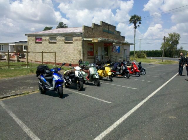
Met up with six other scooter riders in Hamilton this afternoon after reading of a proposed ride as listed on the Scooter Bar FB page. Apart from Grant of the ' Scooter Bar ' I had not met any of the others. Den Shaw was the instigator of this event and had a course plotted out over about 80k. One novice in Ronnie who did damn well for his first ride.
A leisurely run with a stop over at Orini ( where the bloody ice cream shop was closed )
We are hoping, we will get together once a month for a run. It was good to link up with others riding the same machines.
" Rule books are for the Guidance of the Wise, and the Obedience of Fools"
Forum whore
After tea I decided to take a short run around a couple of side roads. It was a beautiful evening. I had wanted to see how my new toy filmed in the low light.
Yesterday, my wife had bought me a new Gopro camera for christmas. It wasn't supposed to be touched until the 25th. After 2 hours of sulking, she couldn't stand having to step over a dropped bottam lip, so Xmas came early
Johnson road is a No Exit road between Te Awamutu and Pirongia. It runs along a saddle and the late sun across the farms below Mt Pirongia showed The best of the patches of bush dotted across the hillsides. The sun was pretty well in front of me on the ride out. This is a snapshot from the Gopro clip.
The shadows took up a bit more of the photo than I had first thought. Just a 1/2hr ride but a warm clear evening rounded up the day nicely.
" Rule books are for the Guidance of the Wise, and the Obedience of Fools"
Forum whore
Did a short run around the back roads yesterday to have a chance to play with my new Gopro. Dont bother watching if listening to Margaret Keys is not your taste. The Gopro was set to 720p @ 30fps HD format.
Last edited by awa355; 21st December 2013 at 04:49. Reason: camera info added
" Rule books are for the Guidance of the Wise, and the Obedience of Fools"
Forum whore
This is an earlier part of the same run. I set the Gopro to WVGA at 60fps just to compare the difference between the Gopro's HD and SD formats.
" Rule books are for the Guidance of the Wise, and the Obedience of Fools"
Rossi wanna be, then I wake up

Great video. Buggsy gets along nicely !
Last edited by frogfeaturesFZR; 20th December 2013 at 21:20. Reason: Spelled Buggsy wrong, D'oh
RSV Mille: No madam, its an Aprilia, not a Harley. If it were a Harley, I would be pushing it !
There are currently 1 users browsing this thread. (0 members and 1 guests)
 Posting Permissions

 Reply With Quote
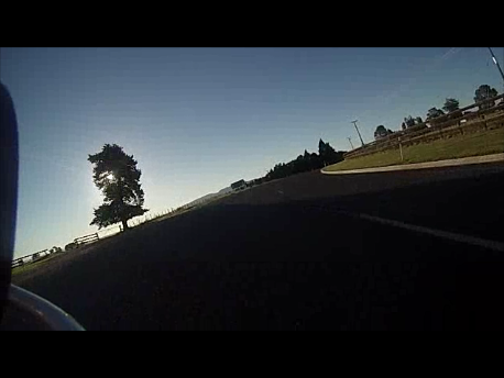
Bookmarks